

Bali Pass Trek a Connecting Ruinsara Valley to Yamunotri Valley in the Garhwal Himalayas Uttarakhand-2025,
Bali Pass Trek lies at the height Altitude of 4953 Meters. The Bali Pass Trek starts from Sankri Base Camp, which is the base camp of more than twenty-five Treks In Uttarakhand, and Ends at Trek Yamunotri Jankichatti.
The Bali Pass Trek comes under Govind Wildlife Sanctuary National Park in Uttarkashi district Uttarakhand. No doubt and the Himalayas have enchanting beauty, a bracing climate, and desirable soothing green meadows.
So, what else can be better than spending some days here in the serenity?
The special thing is that you can also do this trek together with the Har Ki Dun Trek, for which you must have Dehradun to Dehradun for 8 nights and 9 days. includes transport.
Itinerary
Total distance 190 – – 8/9 Hours journey
Mode of journey – By taxi
Altitude Sankri base camp –Altitude- 6291 ft
Night stay – Our Grand Shiva Hotel – on a twin share basis
Himalayan Hikers organizes transport for trekkers from Dehradun Railway Station in the morning which will leave for Sankri around 6:00 am to 7:00 am.
Dehradun is the capital of Uttarakhand and one of the most beautiful places in India. The main attraction of this place is Rajpur road go through it and get a glimpse of Dehradun’s beauty.
Reach Mussoorie after an hour which is also known as “Queen of Hills”. People visit it heavily during vacations with their family and friends. After half an hour, stop at Kempty Fall. Have breakfast there and witness people from different parts of the world. The break will be of a maximum of 1 hour. Ahead the peaks are visible and further you will come close to the holy Yamuna River. If you want, then take a short break of 20 minutes and enjoy being around it.
Further, you will cross the small markets of Nainbagh, Damta, and Naugaon. Reach Purola around 1:30 pm and take a break there for lunch. After having lunch proceed to Sankri via Jarmola. From there the back of Kedarkantha is visible. Go through the picturesque zig-zag road amid the pine forest of Jarmola.
Reach Mori and after 1 hour you will come across a check post. They will ask for Aadhar cards and some other details. Ahead lies Sankri, enjoy the drive and the wait is soon going to be over. Reach trekkers paradise and the main market of Sankri.
Go to Hotel Grand Shiva Swargarohini, freshen up, and enjoy evening snacks on the open terrace with great views. You will be provided some details after which you can go for an evening walk but be at the hotel for dinner.
Enjoy a delicious dinner and spend a comfortable night in the mountains.
Total distance 23 km – 4/5 Hours journey
Mode of journey – On foot – 12 km – By taxi 13 km
Altitude Cheludgad camp – Altitude 8,158 ft
Night Stay – Our Campsite – on a twin share basis
After breakfast, ready for all trekkers we will drive towards Taluka on the way beautiful forest with many species of trees, Taluka is a small village with concrete houses and you can easily find a few shops and hotels there. Trek starts from Taluka and the sight of magnificent snow-clad mountains accompanies you all along the way.
Go ahead, cross a bridge over a stream, and follow the trail. Pass through dense forest and a Supin river on the way is visible flowing through the woods below. Continue trekking and a village named Dhatmir comes into sight.
Ahead lies a lavish green meadow, which further leads to the forest section. The trail changes to a mixture of steep and leveled paths and afterward to muddy.
After some hours of trekking, the Supin River can be seen flowing through the woods. Now, again cross the forest section and reach the green fields and a shop on the way.
From here, cross a bridge and a little higher you are welcomed by the surpassing views of towering peaks. To reach Cheludgad campsite today, set up your camps here and retire for the night. Enjoying the first camping night here.
Trek Distance – 06 Km – 3/4 Hours journey
Mode of the journey – On foot 6 km
Altitude – Devsu Bugyal camp – Altitude 9,795 ft
Night Stay – Our Campsite – on a twin share basis
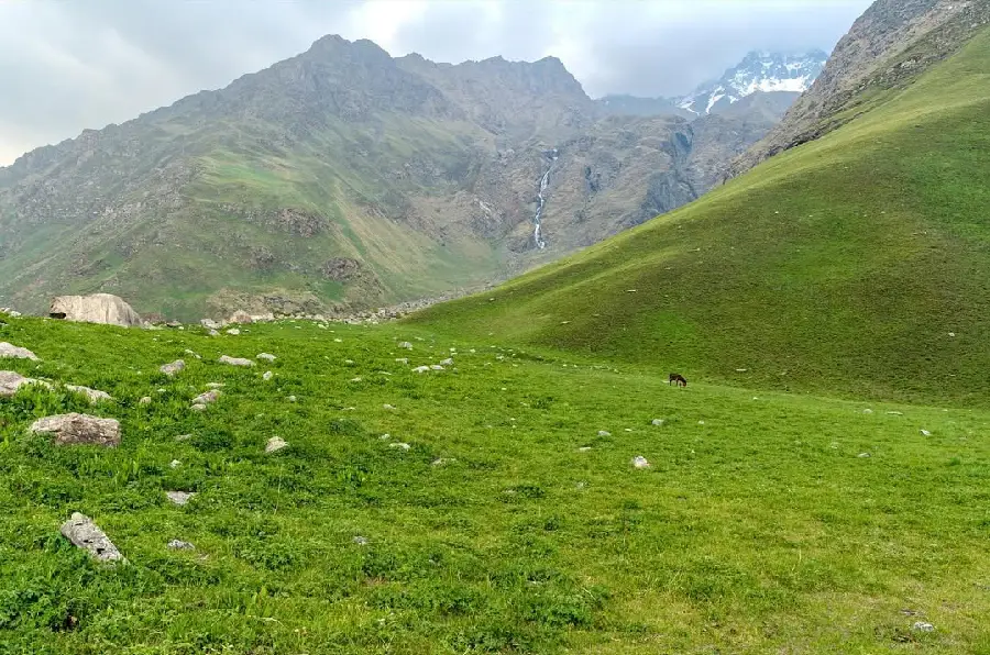
After breakfast start the trek the destination for today is Devsu Bugyal camp on a gradual ascent that offers excellent views of the snow-covered mountains and vast valleys with huge waterfalls.
Devsu Bugyal 2nd camp of Malaria Lake Trek
Through dense forests and spot rare species of Himalayan birds, animals and exotic flowers.
The area is full of birch and spruce.
Ahead, the trail gets steep, crosses the last steep ascent, and reaches Devsu Bugyal. This is beg meadows and grassland, There is greenery all over, enlivening nature and open wide meadows which are perfect for camping. From here spot magnificent Black Peak.
Pitch your tents and enjoy the beautiful mountain life with us
Trek Distance – 10 km – 5/6 Hours journey
Mode of the journey – on foot – 10 km
Altitude – Ruinsara Lake Camp – Altitude 11,720 ft
Night Stay – Campsite – on a twin share basis
Today start trek to Ruinsara Lake is at an altitude of 3500 meters. In the morning after breakfast and with packed lunch, the trek starts to Ruinsara Lake and ascending again offers mesmerizing views of the snow-covered mountains and wide valleys with cascading waterfalls. And enjoying one the way Ruinsara lake river
First, there was a steep descent of about 100 m to the Ruinsara River & then a steady ascent along a beautiful trail that was broken due to landslides at various places – where later during the day the ponies had a lot of difficulties.
Came to an idyllic spot for a nice halt for lunch under trees & over huge boulders.
Every long break is bound to have a photo session!
The area is home to a number of Himalayan birds and animals. Trek through the muddy path, cross the slippery areas carefully and further cross Ruinsara River over a bridge.
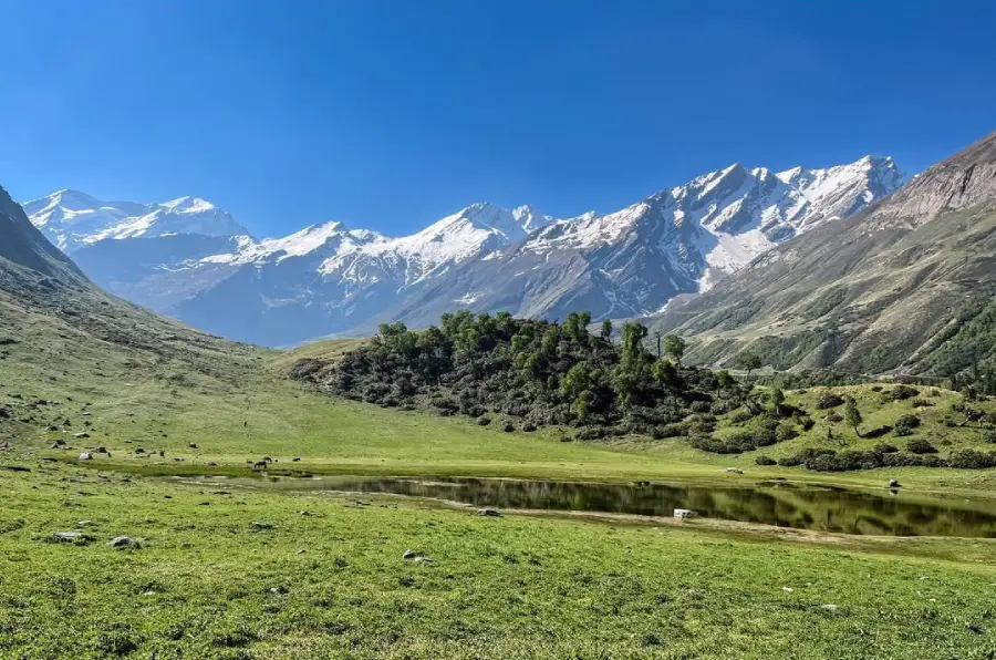
Ruinsara Tal is a freshwater Lake that lies amidst the pristine peaks and is nestled on the foot of Mt. Kalanag. The region is idyllic and turns lush green after the rains of June and August.
From here, you can relish magnificent views of Ruinsara Range, Mt. Kalanag, Bandarpoonch and Swargarohini (I) (II) (III). The base camp of kyarkoti
Ruinsara Tal also beautiful lake surrounding mountain range Ruinsara lake campsite is more beautiful camping in the Himalayas
Tonight you can see full moonlight and star – on your tents
Trek Distance 03 km – 3 Hours journey
Mode of journey – On foot – 03 km
Altitude – Thaga camp – Altitude 13,120 ft
Night Stay – on a twin share basis
The trek from Ruinsara Tal to Thaga Camp on Day 5 of the Bali Pass Trek offers some breathtaking views and takes you through the stunning landscapes of the Garhwal Himalayas. Here’s a brief overview of the route and what you can expect to see:
- Ruinsara Tal (3,600 meters): You will start your trek from the beautiful Ruinsara Tal, a high-altitude glacial lake surrounded by lush meadows and the majestic Swargarohini peaks. This serene and picturesque location is a perfect starting point for the day.
- Initial Ascent: The trail begins with a gradual ascent through alpine meadows and rhododendron forests. You’ll enjoy panoramic views of the surrounding peaks, and if you’re trekking in the right season, the colorful rhododendron blooms can be quite a sight.
- Continuing Ascent: The trail continues to ascend, and you’ll encounter some steep sections as you make your way towards Thaga Camp. The terrain can be rocky and uneven in places, so trekking poles can be handy.
- Thaga Camp (4,200 meters): Thaga Camp is your destination for the day. It’s a high-altitude campsite that offers stunning views of the surrounding peaks, including Bandarpoonch and Kalanag. The campsite is usually located in a grassy area, and you’ll be surrounded by the towering peaks of the Garhwal Himalayas.
- River Crossings: Depending on the time of year and recent weather conditions, you may encounter river crossings on this segment of the trek, so be prepared for these challenges.
Trek Distance 06 km – 4/5 Hours journey
Mode of journey – On foot – 06 km
Altitude Bali Odari camp – Altitude 15,125 ft
Night Stay – on a twin share basis
On Day 6 of the Bali Pass Trek, you’ll be trekking from Thaga Camp to Bali Odari Base Camp. This segment of the trek offers more stunning views and takes you deeper into the high-altitude wilderness of the Garhwal Himalayas. Here’s an overview of the route and what you can expect to see:
- Thaga Camp (4,200 meters): You will begin your trek from Thaga Camp, a high-altitude campsite nestled in the alpine meadows. The campsite offers panoramic views of the surrounding peaks, and you might still have a clear view of the majestic Swargarohini peaks.
- Initial Ascent: The trek starts with an initial ascent, which can be steep and challenging in places. As you gain altitude, the terrain might become rocky and uneven. The route may also involve crossing rocky moraines or glacial areas, so sturdy trekking boots and trekking poles are important for stability.
- Glacial Streams and Moraines: You’ll likely cross glacial streams and navigate through moraines as you make your way towards Bali Odari Base Camp. The landscape becomes more rugged and remote, and the trail can be less defined in some areas.
- Views of the Surrounding Peaks: Throughout this segment of the trek, you’ll be treated to breathtaking views of the surrounding peaks, including Bandarpoonch, Kalanag, and others. The pristine, high-altitude environment is a great place for photography and taking in the grandeur of the Himalayas.
- Bali Odari Base Camp (4,800 meters): Your destination for the day is Bali Odari Base Camp, which is located at an altitude of around 4,800 meters (15,750 feet). This is a high-altitude campsite situated close to the Bali Pass. It offers a dramatic setting with towering peaks all around, making it a fantastic spot for stargazing if the weather is clear.
- Altitude Considerations: As you’ll be trekking to high altitudes, it’s essential to pay attention to how your body is reacting to the increasing altitude and to acclimatize properly to prevent altitude-related issues.
Trek Distance 14 km – 8/9 Hours journey
Mode of journey – On foot – 14 km
Altitude Lower Damni altitude –Altitude 10,111 ft
Night Stay – on a twin share basis
The trek from Bali Odari Base Camp to Lowar Damni Camp via the Bali Pass Summit is one of the most challenging and adventurous parts of the Bali Pass Trek. It involves gaining significant altitude as you cross the pass, and you’ll be rewarded with incredible views of the Himalayan peaks. Here’s an overview of the route and what you can expect:
- Bali Odari Base Camp (4,800 meters): You’ll start your day at the high-altitude Bali Odari Base Camp, which is located at an elevation of approximately 4,800 meters (15,750 feet). From here, you’ll begin your ascent towards the Bali Pass Summit.
- Initial Ascent: The trek begins with a steep ascent as you make your way towards the Bali Pass. The terrain becomes rocky and more challenging, and the air gets thinner as you gain altitude. Trekking poles and appropriate gear are essential.
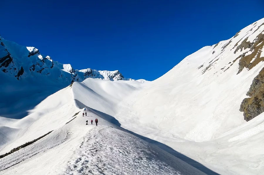
- Bali Pass Summit (4,945 meters or 16,207 feet): The Bali Pass Summit is the highest point of the trek, reaching an altitude of 4,945 meters (approximately 16,207 feet). Reaching the summit is an exhilarating experience. From here, you’ll be rewarded with panoramic views of the surrounding peaks and the valleys below. It’s a great spot for taking in the stunning Himalayan landscape and capturing some incredible photographs.
- Descent to Lowar Damni Camp: After enjoying the views at the Bali Pass Summit, you’ll begin your descent towards Lowar Damni Camp. The descent can be challenging, and the terrain may be rocky and uneven in places.
- Lowar Damni Camp (4,000 meters): Your destination for the day is Lowar Damni Camp, situated at an altitude of approximately 4,000 meters (13,123 feet). This campsite is usually located in a beautiful, remote area surrounded by mountains and alpine meadows.
- Trekking Duration: The trek from Bali Odari Base Camp to Lowar Damni Camp is relatively long and challenging, taking about 8 to 9 hours to cover a distance of around 14 kilometers.
Throughout this segment of the trek, you’ll be surrounded by the breathtaking beauty of the Himalayas, with views of snow-capped peaks and pristine landscapes. It’s essential to be physically prepared and acclimatized for the altitude. Following the guidance of your
Distance – 06 km – 2/3 Hours journey
Mode of a journey – on foot 6 km taxi 175 km
The trek from Lower Damani Camp to Jankichatti via Yamunotri Temple and then traveling to Dehradun by taxi on the same day is quite an ambitious plan, and it would involve a long and tiring day. Here’s what the route and schedule might look like:
Trekking Route:
- Lower Damani Camp (4,000 meters): You’ll start your day at Lower Damani Camp, which is situated at an altitude of around 4,000 meters (13,123 feet).
- Trek to Yamunotri Temple (3,293 meters): You’ll begin your trek downhill from Lower Damani Camp to Yamunotri, which is situated at an altitude of approximately 3,293 meters (10,801 feet). The trek involves descending along the trail and crossing picturesque landscapes.
- Yamunotri Temple: Visit the famous Yamunotri Temple, one of the Char Dham pilgrimage sites, and pay your respects to the deity. It’s essential to check the temple’s opening and closing times, as it might not be accessible at all hours.
Travel to Dehradun: After visiting the temple, you’ll need to travel to Dehradun. The distance between Yamunotri and Dehradun is considerable, and the journey is long and winding. The roads in the region can be narrow and sometimes in poor condition, so it may take several hours to reach Dehradun by taxi.
Considerations:
- The drive from Yamunotri to Dehradun can take approximately 6 to 8 hours, depending on road conditions and traffic.
- It’s a good idea to start early in the day to ensure you have enough time to complete the trek to Yamunotri, visit the temple, and then begin your journey to Dehradun.
This plan is feasible if you have made all the necessary transportation arrangements in advance, are physically fit to complete the trek, and are prepared for a long day of travel. Keep in mind that the trek and the long drive may be physically demanding, so it’s important to ensure you have enough time for rest and breaks during the journey.
Mandatory Documents
Please carry the documents given below
- Original and photocopy of government photo identity card- (Aadhar Card, Driving License, Voters ID, etc,
- Passport and Visa important to foreigners
- Medical Certificate (First part should be filled by the Doctor and Second part by the Trekker)
- Declaration Certificates
What is Included In This Trek?
Transport from Shimla to Shimla Pickup and Drop both way
Forest Permit and entrance fee
Accommodation in tents on twin share basis
Meals: Breakfast, Lunch, Tea, Coffee, Snacks, Soup and Dinner
High quality Dome Tents
Sleeping bags
Mattress